The Teton Mobility Project is a joint project of Friends of Pathways and Jackson Hole Community Pathways (the Town of Jackson and Teton County Pathways program). We’re taking a fresh look at the current pathway and sidewalk system to identify deficiencies and prioritize future improvements.

THANK YOU FOR YOUR INPUT!

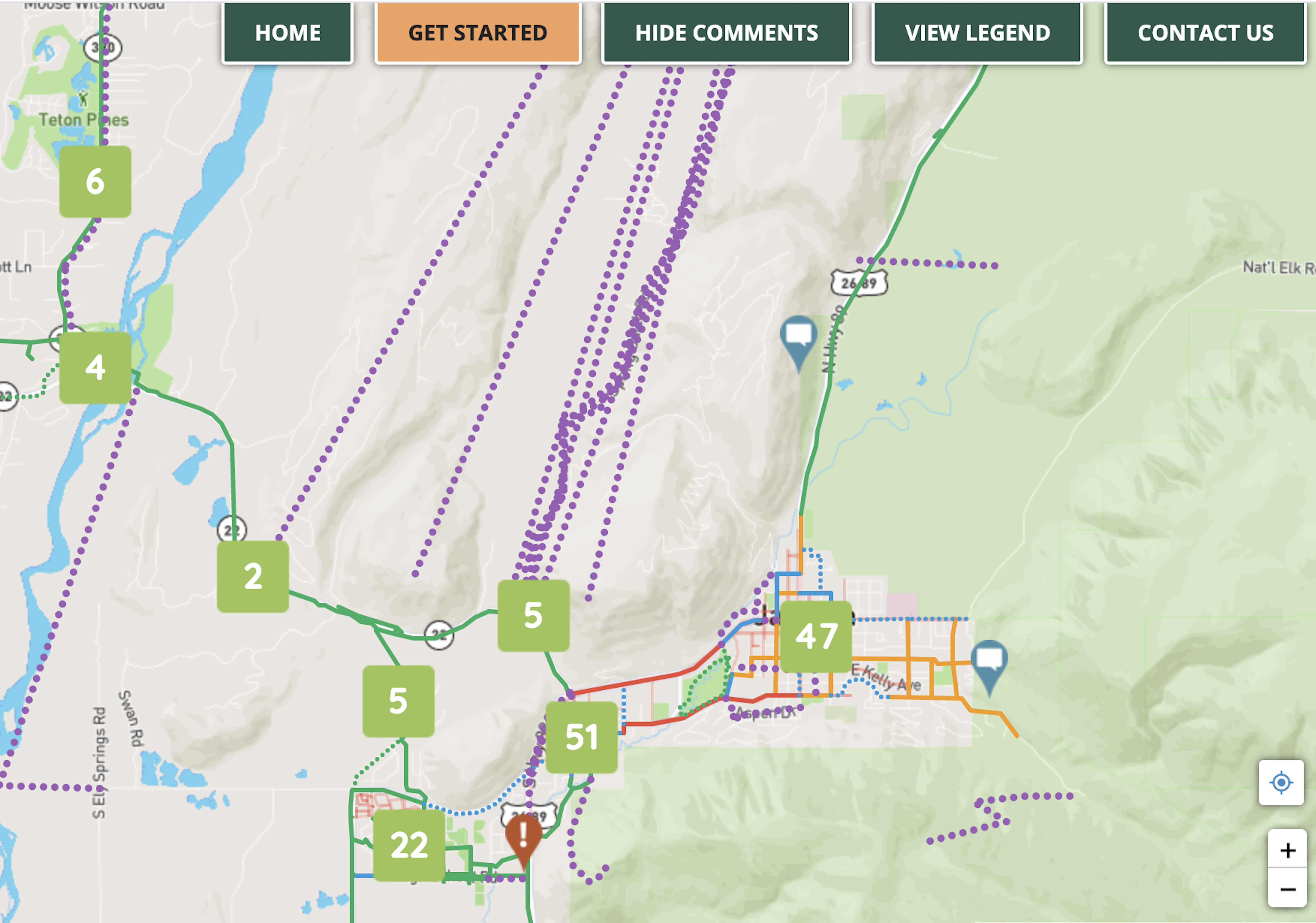
The public comment period concluded on September 15, 2020. Click the button below to see a summary of the public comments about pathway improvements and challenges. 

Why is my participation in the Teton Mobility Project important and how will my input be used?

Through the Teton Mobility Project, we are seeking public input on how the current pathways system is meeting your needs for a safe, interconnected network that supports active transportation and recreation in Teton County, and how future improvements can better serve you. Your input will guide the next 25 years of pathways development and improvement in the Town of Jackson and Teton County.

The development of the pathways, bike routes and sidewalks in Jackson Hole is the result of a significant amount of planning and public input over the past 25 years. There are three primary documents which guide the development of these active transportation networks: (1) The Jackson/Teton County Pathways Master Plan, (2) the Grand Teton National Park Transportation Plan and (3) the Bicycle Improvement Plan for the Town of Jackson. Each plan is managed differently, but all have an overarching goal of supporting non-motorized transportation in Jackson Hole.

The Teton Mobility project is seeking input on pathway, bike lane, sidewalk, and other active transportation projects in Teton County and the Town of Jackson. The 2007 Teton County Pathways Master Plan is long overdue for an update; the plan was only intended to guide system development for 5-10 years, and most of the projects identified in this plan have been built or are well into the design phase.

We are asking you to tell us:

Where would you like to be able to cycle and/or walk but can’t yet due to the lack of infrastructure?
Such as:
• Gaps in the existing network of pathways, bike lanes, and sidewalks
• Neighborhoods and destinations that aren’t currently connected to the pathway system
• Other infrastructure such as bike parking that would make it easier for you to walk and bike for daily trips in Jackson Hole

AND

Where have you experienced situations that feel uncomfortable or unsafe to walk or bike?
Such as:
• Uncomfortable intersections
• Areas with poor visibility
• Pathways and sidewalks in need of repair or improvements
• Areas that make you nervous to ride (or walk) with kids or as a “non-expert” cyclist

Information will be collected and analyzed by Town and County staff to help formulate a list of priority projects. The joint elected boards of the Town (the Town Council) and County (County Commissioners) will have the final approval of the priority list.

Status of Proposed Projects

Sagebrush Pathway is located on Spring Gulch Road and Sagebrush Dr. in Grand Teton National Park and will link neighborhoods along Spring Gulch Road to the GTNP pathway network at the Gros Ventre Junction. It is shovel ready but needs funding for construction.

Wilson to the Snake Pathway is in the design phase and is nearing construction readiness. Teton County has applied for a federal grant that, if awarded, will provide funds to construct this long-awaited pathway segment.

Tribal Trail Pathway is a part of the Tribal Trail Road extension project. The County would construct this pathway segment should it move forward with the connector road project.

South HWY 89 Pathway to Munger Elementary and Hoback Junction is part of the current WYDOT highway widening project and will extend the pathway from Game Creek to Hoback Junction. It is under construction – Phase I from Game Creek to Munger Elementary will be finished in 2020, and Phase II connecting Munger Elementary to Hoback Junction should open in 2022 or 2023.

Karns Meadow Pathway is identified in the Karns Meadow conservation easements as a natural surface pathway around the perimeter of Karns Meadow Park, but has not been formally approved. Teton County Parks and Rec is responsible for the development of the trail.

Teton Pass Pathway will run from Victor, ID to the top of Teton Pass, where it will link with Old Pass Road. It is part of the Greater Yellowstone Trail, a regional trail concept running from Jenny Lake to West Yellowstone via Teton Pass.  https://www.wyopath.org/wp-content/uploads/2016/03/GYT-ConceptPlanScreen.pdf

South Park Road Pathway is part of the Town of Jackson Bicycle Network and would be on the south side of South Park Loop Road from the Middle School to Highway 89. It has not entered the planning phase.

Jackson Bike Routes
In 2015, the Town of Jackson adopted a plan for bike routes to interconnect the county pathways and selected public places, recreational areas, parks and trailheads. Implementation of this plan has occurred in stages and is ongoing.

Different Types of Biking/Walking Infrastructure

Proposed Bike Routes
Bike routes identified in the Town of Jackson Bicycle Improvement Plan but not yet implemented.

Proposed Pathways
These are unconstructed pathway projects identified in the Pathways Master Plan or the Bicycle Improvement Plan. Most are under construction or are in the planning phase.

Pathways
A pathway is a paved walking and cycling facility physically separated from motor vehicle traffic by an open space or barrier.

In some communities, shared-use paths provide different lanes for users who travel at different speeds (a lane for walkers and a separate lane for cyclists) to prevent conflicts between user groups on high-use corridors.

Sidewalks
Sidewalks are a pedestrian walkway, usually parallel to a street or roadway.

Bike Lanes
Bike lanes designate a dedicated space on the street for bicyclists through pavement markings and signage. Bike lanes are (usually) located to the right of motor vehicle travel lanes and flow in the same direction as motor vehicle traffic.

Bike Routes
Bike routes are “low-stress” streets designated as preferred routes for cyclists to share the street with vehicles. This is typically done on streets with low traffic speeds (25 mph or less) and low traffic volumes, where many cyclists are comfortable riding. Bike routes are designated by in- street paint and directional signage.

Separated Bike Lane (also called Protected Bike Lanes or Cycle Tracks)
Separated bike lanes use a curb or other visual and/or physical barrier between the vehicle lane and the bike lane to provide physical separation for cyclists. Separated bikeways are most appropriate on streets with higher traffic and vehicle speeds. Separated bike lanes are attractive to a broad spectrum of the cycling public and provide increased comfort and safety for bicyclists.

Sign up for email updates about the Teton Mobility Project.

Be Today’s Solution!